Flooding in Derby update
Published: 14 November 2019
Read the latest news and updates about flooding in Derby
Update 6.40pm 14/11/2019
Heavy rain throughout the day has left a large amount of surface water on roads around the city. The amount the rainfall has also affected public transport, with severe delays to train and bus services to and from Derby. Please check with your travel provider before travelling.
Road closures
- Staker Lane (closed in conjunction with Derbyshire County Council)
Knightsbridge and Acorn Way both have a large amount of surface water but are open.
Sandbags have been delivered to those residents and businesses in need.
Keep up to date with our Twitter account for updates and please only travel if necessary.
Update 3.35pm 14/11/2019
Despite today’s rain, river levels are not posing an immediate risk. We’re monitoring the situation very closely and will be issuing regular updates on our newsroom if the situation changes. People should be vigilant, but not alarmed.
While there is no imminent risk of the river rising as it did last week, we’re still prepared – 1,000 sandbags and ready to close floodgates if we need to. But the message is not to be alarmed, we’re closely monitoring the situation and will issue updates if things change.
Update 7.20pm 13/11/2019
All roads have now been opened.
Road closures on Haslams Lane, Ford Land and Chequers Rd have been lifted.
Thank you for your patience during the closures.
Update 6.50pm 10/11/2019
Station Approach is now open.
The only road closures left in place are:
- Haslams Lane
- Ford Lane
- Chequers Rd
Please check back for more updates in coming days.
Update 4.30pm 09/11/2019
Thanks to the hard work of the teams, the vast majority of roads are now reopen.
The road closures remaining are on Haslems Lane, Ford Lane and Station Approach.
Please see our updates below:
- Sowter Road – OPEN
- Haslams Lane – CLOSED
- Ford Lane – CLOSED
- Darley Park footpath – OPEN
- Eastgate – OPEN
- Meadow road closed – OPEN
- Raynesway service road – OPEN
- Station Approach – CLOSED
- Pentagon Island – OPEN
- A52 inbound from J25 down to Pentagon Island – OPEN
Update 3.00pm 09/11/2019
The A52 outbound and inbound is now open in its entirety.
Teams are working hard to open up several other road closures as soon as possible today.
Update 11.41am 09/11/2019
A52 Pentagon Derby outbound (east) is now open.
A52 Derby inbound (west) from Spondon is currently awaiting pumping.
Update 09.40am 09/11/2019
Water levels have dropped overnight. Our teams are working hard to clear debris and we will be assessing areas this morning to ensure we can re-open roads when they are safe.
The following road closures are still in place:
- Sowter Road
- Haslams Lane
- Ford Lane
- Darley Park footpath
- Eastgate
- Meadow road closed
- Raynesway service road
- Station Approach
- Pentagon Island
- A52 inbound from J25 down to Pentagon Island
Update 10.15pm 08/11/2019
The water levels have now peaked at 9.00pm at 3.35m.
We are aware of the power shortage in the city centre and we visiting affected residents Exeter House.
Properties in the Chester Green we believe are now out of immediate danger of flooding.
We’ve spoken to the residents living on the ground floor of Exeter House (15 flats in total). The majority of residents have chosen to go to stay with friends or family. We’re still in contact with the small number of remaining residents who have chosen to stay, keeping them updated.
Traffic has reduced, however a number of roads remain closed – see update below.
Please do not travel into the city unless it’s absolutely essential.
Keep up to date with our Twitter account for update throughout today. Please check before travelling and do not drive into flood water or drive on roads that are closed.
Update 9.05pm 08/11/2019
Public transport update
Arriva bus services are still running but are severely delayed.
Trent Barton have now suspended all bus services.
Network Rail have advised that the line north of Derby is likely to remain closed on Saturday due to flooding. This will mean no trains can run between Derby and Matlock. EMR Intercity services will run to an emergency timetable.
Please only travel if necessary.
Keep up to date with our Twitter account for update throughout today. Please check before travelling and do not drive into flood water or drive on roads that are closed.
Update 7.35pm 08/11/2019
Major road closures
A52 is closed inbound from J25 due to flood water on the carriageway.
A61 is closed southbound from Petron Island to Little Eaton junction.
Trent Barton have now suspended all bus services.
Keep up to date with our Twitter account for update throughout today. Please check before travelling and do not drive into flood water or drive on roads that are closed.
Update 6.35pm 08/11/2019
Traffic is still very heavy around the city centre and there are major delays on all routes. We are working hard to manage the traffic flow, please only travel if necessary. There are no buses travelling inbound to Derby, as well as no bus services between Borrowash, Sandiacre, Draycott and Stapleford. Please contact your travel providers before travelling.
The following roads are now closed:
- Sowter Road
- Haslams Lane
- Ford Lane
- Darley Park footpath
- Eastgate
- Meadow road closed
- Raynesway service road
- Station Approach
- Pentagon Island
Keep up to date with our Twitter account for update throughout today. Please check before travelling and do not drive into flood water or drive on roads that are closed.
Update 4.30pm 08/11/2019
Derby Bus Station is still open but is experiencing major delays on all routes. Please contact your bus provider for travel updates.
Keep up to date with our Twitter account for update throughout today. Please check before travelling and do not drive into flood water or drive on roads that are closed.
Update 3.45pm 08/11/2019
Derby Bus Station is currently being evacuated. Please contact your bus provider for travel updates.
We are gritting the whole network of Derby roads this evening as the temperature is expected to go below freezing. Additional salt is being added to prevent surface water freezing.
Eastgate underpass is now closed with the assistance of Derbyshire Police.
The river is expected to raise to up to 3.2m this evening. Visit the Flood Information Service website for ongoing updates.
Do not travel to known flooded areas. Please stay away from standing water.
Keep up to date with our Twitter account for updates throughout today. Please check before travelling and do not drive into flood water or drive on roads that are closed.
Update 2.46pm 08/11/2019
Meadow Road and Meadow Road elevated footpath have now been closed due to the close proximity to the rising water level.
Eastgate underpass heading into St Alkmunds Way has standing water and is currently unpassable.
Keep up to date with our Twitter account for updates throughout today. Please check before travelling and do not drive into flood water or drive on roads that are closed.
Update 1.30pm 08/11/2019
Further flood gates have now been closed at Duke Street and St Mary’s Place. Road closures are in place. Please follow diversion signs.
Keep up to date with our Twitter account for updates throughout today. Please check before travelling and do not drive into flood water or drive on roads that are closed.
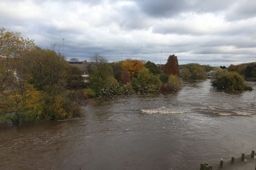
The river levels have risen overnight and during this morning causing areas of localised flooding along the Lower Derwent north of the city centre.
We have closed flood gates at Haslams Lane, Waterside Inn, Darley Playing Fields and the Sowter Road Pumping Station. The swing bridge next to the Silk Mill has been closed to pedestrians. Ford Lane in Allestree has also been closed and will affect local traffic.
There is currently risk of flooding in the Raynesway area. We are working with businesses to ensure they can continue with business as usual.
We are currently taking the following steps:
- Reviewing river levels and closing flood gates in certain areas of the city
- Road closures will be in place in areas of low level flooding or where a flood gate has been closed
- We are working with Derbyshire County Council, Derby Fire and Rescue and Derbyshire Constabulary throughout this time
Keep up to date with our Twitter account for update throughout today. Please check before travelling and do not drive into flood water or drive on roads that are closed.